Stuttgart – Bosch and the Dutch map and traffic information provider TomTom have achieved a breakthrough in the development of high-resolution maps for automated driving. The supplier of technology and services has become the first worldwide to create a localization layer using radar signals – which will be indispensable for maps like these. So far, video data has been used for this purpose. Bosch’s “radar road signature” is made up of billions of individual reflection points. These are formed everywhere that radar signals hit – for example, on crash barriers or road signs – and reproduce the course a road takes. Automated vehicles can use the map to determine their exact location in a lane down to a few centimeters. “The radar road signature is a milestone on the path towards automated driving. It will enable automated vehicles to reliably determine their location at all times,” says Bosch board of management member Dr. Dirk Hoheisel. The huge advantage of Bosch’s radar road signature is its robustness: unlike maps that rely exclusively on video data for vehicle localization, the radar road signature also works reliably at night and in conditions of poor visibility. Moreover, the Bosch radar road signature only transmits five kilobytes of data to a cloud per kilometer – this data volume is twice as high using a video map. It is expected that by 2020 at the latest, the first vehicles will provide data for the radar road signature in Europe and the U.S.

Bosch and TomTom have been collaborating since 2015
“We are delighted to be able to introduce supplemental localization data in the form of the radar road signature in partnership with Bosch. It will make self-localization for automated vehicles considerably more robust in every respect,” says TomTom’s CEO Harold Goddijn. The two companies have been working intensively on the radar road signature and its integration into TomTom’s high-resolution overall map since the beginning of their collaboration in July 2015. Bosch is a global market leader in the field of radar sensors with 77-gigahertz technology and detection ranges of up to 250 meters. By comparison, video sensors only have a maximum detection range of 150 meters. The main challenge was finding a way to adapt existing radar sensors for this task. When used in a driver assistance system such as automatic emergency braking systems or adaptive cruise control (ACC), the sensors detect moving objects. But in order to generate the radar road signature, they also need to be able to detect static objects, which meant that existing radar sensors had to be modified. The next generation of Bosch radar sensors will be able to provide the data required for the radar road signature. “Cars arriving on the market in years to come with the assistance functions of tomorrow will be running the map for the automated vehicles of the future,” Hoheisel says.
One million vehicles will keep the high-resolution map up to date
High-resolution maps are essential for automated driving and provide information that goes beyond the area that sensors are able to monitor. Unlike maps for today’s navigation devices, they are made up of a number of overlapping layers:
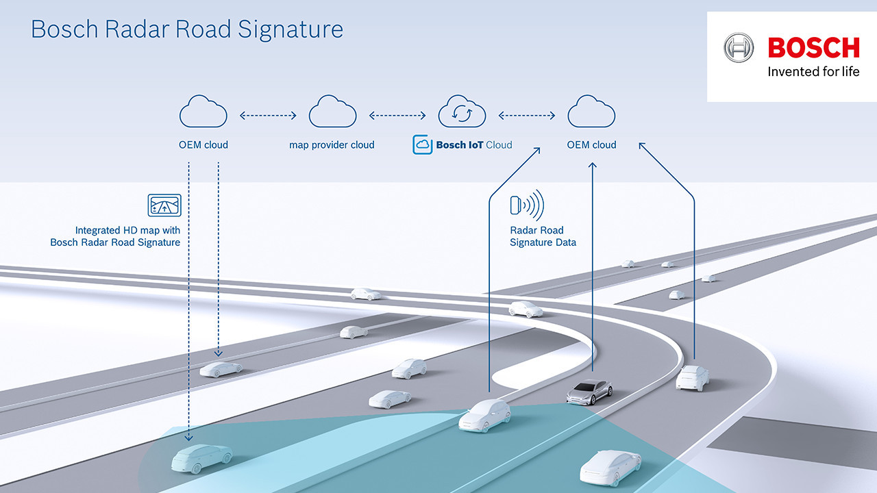
Localization layer: An automated vehicle can determine its position in a lane by using a localization layer comprising the Bosch radar road signature plus an additional video localization map. It compares information about objects that it has received via its surround sensors using the corresponding information from the localization layer. In this way, the vehicle can determine its relative position to these objects.
Planning layer: The planning layer is used to calculate individual maneuvers during automated driving (trajectory planning). The planning layer also contains information about the course of the road, traffic signs and speed limits, as well as bends and gradients. An automated vehicle can use the planning layer, for example, to decide when it should change lanes.
Dynamic layer: Information about any rapidly changing traffic situations such as traffic jams, construction work and hazards, or available parking spaces is saved in the dynamic layer.
Each of these layers of a high-resolution map for automated driving need to be regularly updated – the dynamic layer even in real time. “We currently expect that we will need fleets for freeways in Europe, North America, and Asia Pacific that each consist of around one million vehicles in order to keep our high-resolution map up to date,” says Hoheisel. Current data for each of the layers will be generated by the vehicles’ on-board sensors while they are driving. Communication boxes such as Bosch’s Connectivity Control Unit will transmit the radar sensors’ data from the vehicles to the manufacturers’ cloud and then on to the Bosch IoT Cloud. Bosch will use this to create the radar road signature, which is compatible with all conventional map formats. TomTom’s responsibilities will include integrating the radar road signature in the overall map and distributing it.
Mónika Hack
+36 70 510 5516
Mobility Solutions is the largest Bosch Group business sector. In 2016, its sales came to 43.9 billion euros, or 60 percent of total group sales. This makes the Bosch Group one of the leading automotive suppliers. The Mobility Solutions business sector combines the group’s expertise in three mobility domains – automation, electrification, and connectivity – and offers its customers integrated mobility solutions. Its main areas of activity are injection technology and powertrain peripherals for internal-combustion engines, diverse solutions for powertrain electrification, vehicle safety systems, driver-assistance and automated functions, technology for user-friendly infotainment as well as vehicle-to-vehicle and vehicle-to-infrastructure communication, repair-shop concepts, and technology and services for the automotive aftermarket. Bosch is synonymous with important automotive innovations, such as electronic engine management, the ESP anti-skid system, and common-rail diesel technology.
The Bosch Group is a leading global supplier of technology and services. It employs roughly 390,000 associates worldwide (as of December 31, 2016). The company generated sales of 73.1 billion euros in 2016. Its operations are divided into four business sectors: Mobility Solutions, Industrial Technology, Consumer Goods, and Energy and Building Technology. As a leading IoT company, Bosch offers innovative solutions for smart homes, smart cities, connected mobility, and connected manufacturing. It uses its expertise in sensor technology, software, and services, as well as its own IoT cloud, to offer its customers connected, cross-domain solutions from a single source. The Bosch Group’s strategic objective is to deliver innovations for a connected life. Bosch improves quality of life worldwide with products and services that are innovative and spark enthusiasm. In short, Bosch creates technology that is “Invented for life.” The Bosch Group comprises Robert Bosch GmbH and its roughly 440 subsidiaries and regional companies in some 60 countries. Including sales and service partners, Bosch’s global manufacturing and sales network covers nearly every country in the world. The basis for the company’s future growth is its innovative strength. At 120 locations across the globe, Bosch employs some 59,000 associates in research and development.
Additional information is available online at www.bosch.com, www.iot.bosch.com,
www.bosch-press.com,
www.twitter.com/BoschPresse, www.bosch.hu